
Yes, that’s snow in late June in Arizona
This wasn’t a fun trip but it was rewarding and educational. I don’t regret doing it. Overall, the hike to the highest point in Arizona was an ordeal. The required degree of exertion was on par with the two marathons (26.2 miles) I ran when I was in my thirties. These are the potential fun-killers I’ve identified thus far:
- My level of fitness wasn’t high enough
- I got dehydrated
- I didn’t eat enough on the trail
- I wasn’t acclimatized (aka acclimated) to the altitude
- I’m too old for this (60)
The Route

The trail was easy to follow but it’s a good idea to have a map “just in case”
I took Humphreys Peak Trail #151, the most common way to the summit. The trailhead is at a parking lot adjacent to Arizona Snow Bowl, a ski area resort. Elevation at the trailhead is 9,320 feet above sea level. (I live at about 2,000 feet above sea level.) The round trip to the summit is about 10 miles. The tree line is at 11,500 feet and the summit is at 12, 633 feet.
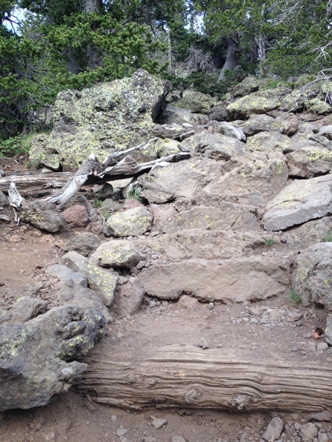
Most of the trail is more chaotic than this
The first half of the trip is unrelentingly upward, about 3310 vertical feet. The footing is mostly rocky. Many other portions have exposed tree roots just waiting for a tired hiker they can trip. Often the rocks and roots share the trail. There are rare patches of smooth dirt without obstacles. When you’re moving you have to keep your head down and on the trail at all times. By the end of this trip, I never wanted to see another rock for as long as I lived.

Trail crossing a river of rocks
There are a few places you have to scramble over isolated boulders, meaning you have to use your hands as well as your feet. At no point do you need technical climbing equipment if you’re hiking in the warm season.
Other than the summit, the other prominent geologic feature on the trail is “The Saddle.” It’s a high-altitude ridge between two of the San Francisco Peaks, shaped like the seat of a saddle.

The Saddle between Agassiz and Humphreys Peaks
My Pace
It took me three hours from the trailhead to reach the Saddle at 11,500 feet. From there, you’ve got another 1.5 miles of hiking to Humphreys’ summit, which took me another 1.5 hours. This last portion is no steeper than the trail to the Saddle; the problem is the thin air. Either that or something else slowed my pace to 1/2 mile per hour!

About half way down from the peak
So it took me 4.5 hours to reach the summit. I had to stop frequently to catch my breath and regain some energy over a minute or two. Five-minute hydration breaks were amazingly refreshing. Slogging uphill, my heart rate was consistently about 160 beats a minute. Even after sitting and resting for five minutes, my heart rate would drop only to 130. Walking on the flat at 11,000 feet was fairly easy, but adding any elevation was almost immediately taxing.
At the summit I was greeted with five minutes of very light rain and sleet.
The trip down took 3.5 hours and was much easier, with far fewer resting spells.
This trail on a Saturday morning (June 27, 2015) was what I’d call crowded. It was as busy as Pinnacle Peak Trail, a popular urban hike in Scottsdale, AZ. I estimate 800–1,000 people were hiking. The large trailhead parking lot was full and overflowing at 9:30 AM when we arrived. The serious hikers are on the trail at 6 AM (good idea). Many folks stop and enjoy the fantastic views at the Saddle, then go back down.

My daughter snapped this picture of me in the parking lot at the trailhead
If you read other people’s trip logs, you’ll find many reporting five to eight hours to complete the hike. My time was 8.5 hours, including 30 minutes resting and enjoying the summit. A couple of times I seriously thought about quitting and turning around. But I knew if I did, I’d probably never attempt this again. It’s been on my bucket list for a decade. Plus,my wife and children made the trip to Flagstaff with me; their presence spurred me on to complete the trip.

I don’t look too miserable, do I?
What Could Have Kept Me From Enjoying the Trip?
1) My fitness level wasn’t high enough.
I’m not buying that, mainly because it’s now the day after and I have no muscle soreness at all. I feel good.
I’ve been training for this trip for six months. My Boy Scout troop and I did a 20 mile hike in March. For the preceding three months we did training hikes every two weeks, starting with six miles, then eight, several 10s, and finally 12 miles. Granted, all those were on the flat. To maintain my fitness thereafter, every week or so I walked Pinnacle Peak Trail, starting at my front door, walking to the west trailhead, then back home, a five-mile hike. I carried a 15-lb dumbbell in my pack to enhance the training effect during this two-hour hike.
2) I got dehydrated.
This probably has some validity. I carried with me 4.2 quarts of water and drank 3.6 quarts. I made a point of stopping every 30 minutes for a hydration break. I sweated a fair amount. I never “felt” dehydrated. Yet I never urinated during this 8.5 hour trip. That’s a huge clue.
My backpack probably weight 20 pounds at the start. The majority of that was water weight. At this altitude you don’t want to be lugging around unnecessary weight. If I ever do a similar trip, I’ll be sure to “fill my tank” by drinking lots of water just before starting, and carrying more water to drink on the trail. I’ll minimize backpack weight some other way.
3) I didn’t eat enough on the trail.
Maybe, but probably a minor issue if at all. I ate two large handfuls of cherries and 400 calories of peanut butter crackers. I had some sweet and salty trail mix but didn’t eat it. I wasn’t hungry. I wonder if that’s an altitude effect. Considering the number of calories I was burning, more food might have helped.
4) I wasn’t acclimated to the altitude.
I think this is the major reason I didn’t enjoy the trip. Our bodies need time to get acclimatized to the low oxygen levels at high altitude. How much time? Probably three to five days staying at 7,000 feet or higher; the longer the better. You might be able to speed up the process by staying at higher altitudes, if only temporarily.

A thunderstorm probably 20 miles away, but I kept a close eye on its movement
Lots of us low-landers have trouble simply sleeping at 8,000–9,000 feet above sea level. Why? We’re not acclimated. On the other hand, if we’re sedentary and awake during the day, we may not have any trouble at those altitudes.

The San Francisco Peaks Groundsel is only found on this mountain. It’s an alpine tundra plant.
While I was hiking, my wife and children rode the ski lift up to 11,000 feet. They all felt slightly short of breath even at rest; much more so with exertion. My daughter also noticed the increased urination many experience at altitude.

Another alpine tundra flowering plant
If I ever do this hike again, here’s what I would do to acclimate. Establish a base of operation in or around Flagstaff at 7,000–8,000 feet. That’s where I’ll sleep intermittently for three to five days. I’ll make periodic forays to higher altitudes. Examples would be picnics, sight-seeing, easy short hikes to 10,000 feet, even a few trips on the ski lift to 11,000 feet and spend a couple hours up there.

On the final push from the Saddle to the summit
The most astounding thing I saw on this trip was un-athletic-looking 16 to 20-year-old girls making it to the summit with apparent ease. Good for them! A lot of hikers on the trail, you can look at their calf muscles and tell they’re either serious hikers or relatively athletic. The girls I’m talking about were slender but had calves like your typical cough potato: small, undefined. I suspect these girls live in Flagstaff, which is a college town (Northern Arizona University), and are acclimated to the altitude. Nevertheless, a 10-mile hike gaining 3,000 vertical feet of elevation is something most untrained folks cannot do even if they start at sea level.

A huge river of boulders
Thankfully, I didn’t get high altitude sickness this trip. My wife got a pretty bad case of it here 23 years ago and did the smart thing: headed down the mountain post haste. Some people take Diamox (acetazolamide) to prevent and treat altitude sickness.
5) I’m too old for this (60)
Quite possibly, but I’m not ready to give up. I saw 15–20 people at the summit, and they were all in the 16 to 40-year-old range. Elsewhere on the trail I did see a few folks who looked older than me. For me to investigate how much of a role my age played in this ordeal, I’d have to repeat the hike, but with optimal acclimatization, hydration, and nutrition.
If any of you experienced mountain climbers have any advice for me, please share. For decades I’ve fantasized about climbing Longs Peak in Colorado; it tops out at 14,259 feet and requires a 5,000 foot vertical climb. I’m less inclined now.
PS: After extreme physical exertion, I get painful leg cramps over the subsequent 24 hours. I seem to be able to suppress them by taking, immediately after exertion, mineral supplements: magnesium, potassium, and calcium. Unless you know you’re entirely healthy, check with your physician before you try this.

The last 100 yards of the hike

A fake farmer’s tan caused by dirt